


Ste Anne du Castelet

bernir
User
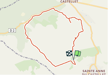

Length
10.3 km

Max alt
434 m

Uphill gradient
282 m
Km-Effort
14.1 km

Min alt
178 m

Downhill gradient
280 m
Boucle
Yes
Creation date :
2022-03-03 08:55:17.295
Updated on :
2022-03-03 23:31:13.738
5h06
Difficulty : Easy

FREE GPS app for hiking
 SityTrail
IGN / Geographical institutes
SityTrail Plus
The world is yours!
About
Trail Walking of 10.3 km to be discovered at Provence-Alpes-Côte d'Azur, Var, Le Castellet. This trail is proposed by bernir.
Photos

Positioning
Country:
France
Region :
Provence-Alpes-Côte d'Azur
Department/Province :
Var
Municipality :
Le Castellet
Location:
Unknown
Start:(Dec)
Start:(UTM)
723539 ; 4790199 (31T) N.
Comments